Aller au contenu principal
Weather
Map
SG
Voir les favoris
sg
New Caledonia Tourism: The official website for tourism in New Caledonia
Discover the archipelago
Aerial view of Nouméa
©
Aerial view of Nouméa
Nouméa
Top experiences in Nouméa
Amédée Lighthouse
Tjibaou Cultural Centre
Nouméa's bays
Aquarium des Lagons
All things to do and see in Nouméa
Kiki Beach, Lifou
©
Kiki Beach, Lifou
The Islands
Top island experiences
Isle of Pines
Ouvéa
Lifou
Maré
All things to see and do in the Islands
Livestock arrival at Néméara farm, Bourail
©
Livestock arrival at Néméara farm, Bourail
West Coast
Top West Coast experiences
Bourail
La Foa - Farino
Koné - Voh - Pouembout
Poum - Koumac
All things to do and see on the West Coast
Linderalic rocks, Hienghène
©
Linderalic rocks, Hienghène
East Coast
Top East Coast experiences
Hienghène
Poindimié
Thio
Hienghene’s hen and rock formations
All things to do and see on the East Coast
Bivouac at Parc de la Rivière Bleue, Yaté
©
Bivouac at Parc de la Rivière Bleue, Yaté
Great South
Top Great South Experiences
Yaté
Mont-Dore
Blue River Provincial Park
Casy islet
All things to do and see in the Great South
Must-see places
Geography & biodiversity
History of the archipelago
10 reasons to come
Things to do
Snorkeling with a lagoon turtle
©
Snorkeling with a lagoon turtle
Heavenly lagoon
Beaches and islets
Diving
Snorkelling
Fishing
Sailing and navigation
Whale watching
Birdwatching at Parc des Grandes Fougères
©
Birdwatching at Parc des Grandes Fougères
Preserved nature
Hiking, walking, trail running
Horse Riding
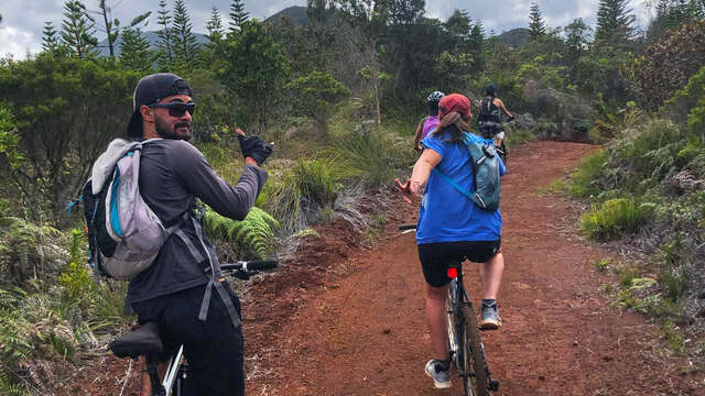
Mountain biking and cycling
Scenic flights
Kayaking
Preserved natural spaces
Traditional Kanak dancers
©
Traditional Kanak dancers
Authentic cultures
Kanak culture
Bush culture
Local Art
Museums
Heritage
Not-to-be-missed events
Lobster on the beach facing the lagoon, New Caledonia
©
Lobster on the beach facing the lagoon, New Caledonia
Local gastronomy
Local products
Local cuisine
6 dishes to try in New Caledonia
Where to eat Bougna?
Relax overlooking the lagoon on Île des Pins
©
Relax overlooking the lagoon on Île des Pins
Leisure and relaxation
Nightlife
Spa and wellness
Golf
Romance
Top relaxing experiences
Sustainable tourism
Family
Inspiration
Top 50 experiences
Plan your trip
Accommodation
Hotels
Youth hostels
Gîtes
Campsites
Tribal stays
Residences
Eco-responsible
All accommodations
Bar at the Sheraton Deva Hotel in Bourail
©
Bar at the Sheraton Deva Hotel in Bourail
Bars and restaurants
Road trip to Hienghène
©
Road trip to Hienghène
Transport
Fête Nationale in Nouméa
©
Fête Nationale in Nouméa
Calendar of Events
Travel guide
Passport, visa and customs
Plan your trip from A to Z
Airport information
Travel specialist
Flights to New Caledonia
Mobile Internet
Arriving by boat
Money and currency
Health & Safety
Weather and seasons
Traditions
Useful contacts
Brochures
FAQ
Getting around
Itineraries / Road trip
Homepage
Agathi Trail
Agathi Trail
Sport
Pedestrian sports
Hiking itinerary
Elevation : 275m
Direction Yaté par la RP1, 98834 Yaté
Getting there
×
Open the itinerary in
Google Maps
Apple Plans
Waze
Mappy
Share
Ajouter aux favoris
Add to my favorites
×
Share this sheet
Agathi Trail
E-mail
WhatsApp
Facebook
X
LinkedIn
Pinterest
©
@J.F.Clair
©
@J.F.Clair
×
©
@J.F.Clair
©
@J.F.Clair
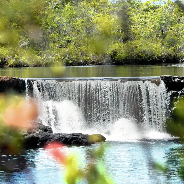
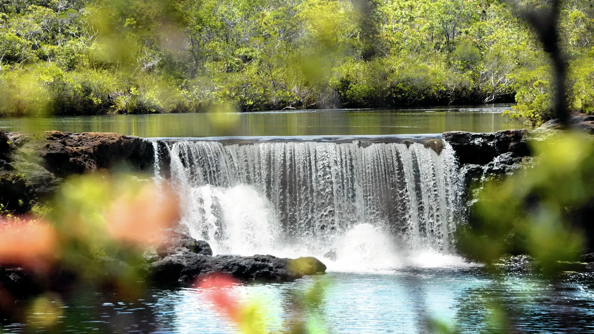
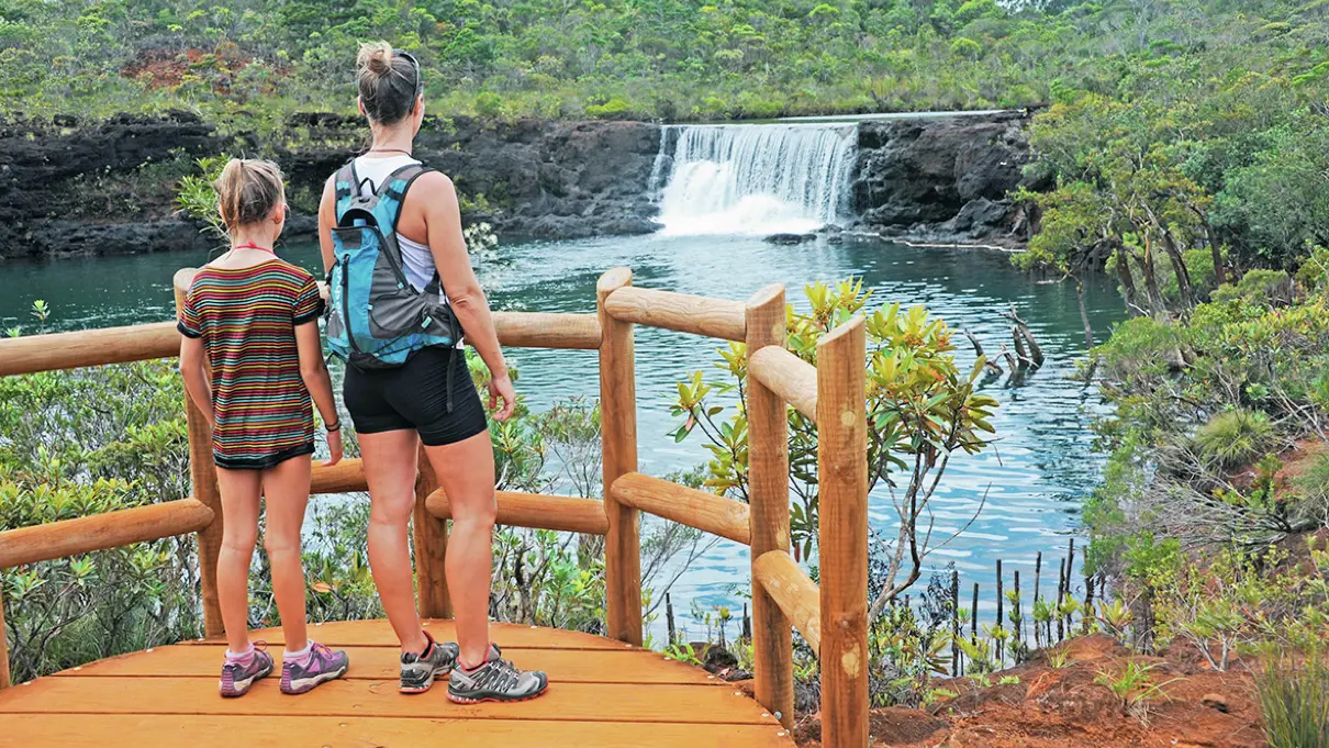
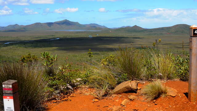
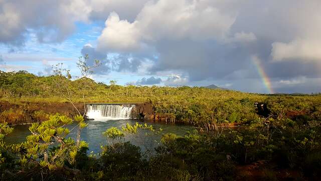
The Agathis trail leads to the natural reserve of the Madeleine Falls. A botanical path runs through it and highlights the remarkable species of the mining maquis.
> Swimming is prohibited. Entrance fee for the reserve and the Netcha site. No water point on the track. D Netcha reception desk (GPS: 690 330 – 7 541 313; alt. 244 m) (payment of entrance fees. No dogs allowed): take the path which goes down in the basin towards the south. It then climbs gently towards the road (RM 10). However, a short distance before this, it veers to the left (towards the east) and joins the road further on (slippery ground in wet weather). 1 Road (GPS: 690 602 – 7 541 059; alt. 242m): cross and climb the foothills of red earth (slippery in rainy weather). There is a small change in the terrain. 2 Hillock (GPS: 690 647 – 7 540 988; alt. 267m) (lookout point over the river and the surrounding area): cross the saddle of red earth and resume the ascent. 3 Intersection (GPS: 690 596 – 7 540 871; alt. 284 m): leave the route shared with the GR® NC1 and turn left towards the east. The path goes down into a thalweg, then it goes up on an undulation of the ground and goes down again into a deeper thalweg, which is filled with vegetation and traversed by a stream. 4 Creek (GPS: 690 851 – 7 540 556; alt. 260 m): leave the small canyon by stairs cut in the red earth and join the road (RM 10). Cross it to find the continuation of the path which enters a low forest before joining the route of the botanical path. 5 Intersection (GPS: 690 950 – 7 540 528): turn right. The trail winds through the undergrowth, adapting to the terrain (educational panels). It leads to an area of red earth which constitutes the car park of the Madeleine botanical reserve. 6 Car park (GPS: 691 421 – 7 540 433; alt. 260 m): continue to the entrance. 7 Reception (GPS: 691 475 – 7 540 444; alt. 257m): immediately afterwards, at the fork, continue straight ahead. Pass the information panels and, at the next crossroads, turn right towards the south to reach another intersection (going straight ahead, it is possible to reach point 10 directly and thereby to shorten the route without going to the Madeleine Falls). 8 Intersection (GPS: 691 605 – 7 540 304; alt. 256 m): turn left towards the east, then, at the next fork, go down the dirt stairs to the small lookout by the river. Cross a creek on a wooden culvert and walk along a stand of bois-bouchons (“corkwood trees”) (Retrophyllum minor: the species owes its name to its lightness, comparable to that of balsa; it is very sensitive to fire, trampling and mutilation by campers; the nature reserve of the Madeleine Falls has ensured its preservation). Climb the blackish dried earth blocks to reach the promontory that dominates the body of water. 9 Madeleine Falls (GPS: 691 761 – 7 540 297; alt. 253m): return to the same route. After the stairs, turn right to go to the viewpoint. 10 Observation deck (GPS: 691 717 – 7 540 417; alt. 253m): the path continues on the other side of the pontoon, towards the north. At the first intersection that follows, turn right (the path on the left returns to the reception office) to follow the river above (some beautiful viewpoints overlook the dark green water) and reach the gauge which records the variations river level. 11 Gauge (GPS: 691 754 – 7 540 671; alt. 255m): turn left and climb a few stairs to reach a new crossroads. 12 Fork (GPS: 691 684 – 7 540 663; alt. 256m): go right towards the north and continue along the river. Alongside it, the path curves to the left (westwards) (stands of gum oaks, Arillastrum gummiferum, on the other bank). Reach the next point. 13 Intersection (GPS: 691 020 – 7 540 717; alt. 242m): continue straight ahead (the botanical path leaves the route and turns left towards the south). The track comes out near the RM 10. 14 Road (GPS: 690 957 – 7 540 781; alt. 239m): walk between the road and the river to return to point 1 then to the Netcha site. © Text by Jean Francis Clair FFrandonnée® grading * Effort: IBP 18 easy (green) * Technical difficulty: easy (green) * Risk: low (green) * Overall grading: easy (green)
Read more
Plain text period
All year round between 8 am and 5 pm.
Services
Picnic area
Covered picnic area
Barbecue
Car park
Sustainable development
Outhouse
Free car park
Documentation
WPT Agathis
Fiche descriptive
Environment
Close to GR footpath
Overview on river
In a nature reserve
On the premises
Includes a section corresponding to...
GR® NC1 Stage n°2 : from the Neocallitropsis refuge in Netcha
Leaving the Neocallitropsis Hut behind, you'll walk the long ridge line that separates the Plain of Lakes from the Pernod Creek Valley. From this low balcony, you will dominate...
Mont-Dore
The Netcha Loops
The trails are freely accessible, the starting points are located all along the Route du Carénage. There is no mountain bike rental on site, please bring your own mountain bike...
Yaté
Madeleine Falls
In the heart of the Great South, the waterfalls and nature trail that lead to them provide a rich walking environment.
Yaté
Close
Popular searches
{% label %}
Filter search
Filter search
Tourist Offers
Business Offers
Page types
All
Articles
Agenda
Lists
Aucun résultat
/
Singapore
Français
Australian
New Zealand
日本語
Trade & Médias
Close
×